
The Traboulay PoCo Trail: A Complete Guide to Port Coquitlam’s 25 km Loop
A flat 25 km loop that circles the whole city: riverside forest, dike-top mountain views, one of the region’s best birding marshes and a salmon creek. Here’s how to ride or walk it, where to start, how long each section takes and what not to miss.
Quick Answer
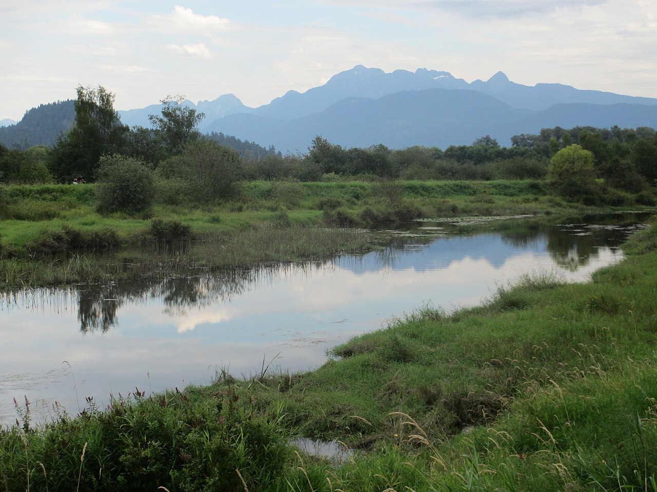
The Traboulay PoCo Trail is a 25 km (25.3 km by the City’s leg-by-leg distances), mostly flat loop around Port Coquitlam that follows the Coquitlam River, DeBoville Slough and the Pitt River. It’s open to walkers, runners, cyclists, skaters and horseback riders. The full loop takes about 5½–6 hours on foot or 2–3 hours by bike with stops. The easiest starts are Hyde Creek Recreation Centre (1379 Laurier Ave), Gates Park (2300 Reeve St, washrooms and a bike repair station) and Shaughnessy Street by the PoCo Climb. Don’t miss the Golden Ears views from the North Pitt River dike, the birds in ƛ̓éxətəm (Colony Farm) Regional Park, and the salmon in Hyde Creek every October and November.
| At a glance | |
|---|---|
| Length | 25 km loop (25.3 km leg by leg) |
| Terrain | Essentially flat; the only real climbing is the optional PoCo Climb stairs |
| Surface | Paved downtown and along the South Pitt River; gravel north of Lougheed Hwy; unpaved dike along DeBoville Slough and the North Pitt River |
| Who can use it | Walkers, runners, cyclists, skaters and horseback riders. Dogs on leash. No motor vehicles. |
| Full loop time | About 5 hr 40 min walking (4.5 km/h) · about 1 hr 40 min cycling (15 km/h), plus stops |
| Best starts | Hyde Creek Rec Centre · Gates Park · Shaughnessy St / PoCo Climb |
| Cost | Free |
| Official map | City of Port Coquitlam Trail Map & Guide (printed copies at City facilities) |
Why this trail is worth your weekend
Plenty of cities have a riverside path. Very few have one that goes all the way around the city. The Traboulay PoCo Trail does exactly that: you can leave from almost any Port Coquitlam neighbourhood, follow the water in one direction, and end up back where you started without retracing a step.
It also changes character every few kilometres. The north side is open dike with farmland on one side, the Pitt River on the other and the Golden Ears filling the skyline. The south side runs past working river industry and the cable-stayed Pitt River Bridge. The west side drops into the marshes of ƛ̓éxətəm Regional Park, then turns into a shaded, paved river path through downtown. That variety is why people come back to it for years, one section at a time.
The loop, leg by leg
The City’s trail guide splits the loop into ten legs between well-known landmarks. The diagram below spaces them by distance so you can see at a glance where the long stretches are. Times assume an easy walking pace of 4.5 km/h and a relaxed cycling pace of 15 km/h, without stops.
On a phone, swipe the table sideways to see every column →
| Leg (clockwise) | Distance | Walk | Bike | What you’ll find |
|---|---|---|---|---|
| Hyde Creek Rec Centre → DeBoville Slough Coquitlam River / Hyde Creek | 1.8 km | 24 min | 7 min | Gravel. Creekside forest, Hyde Creek hatchery side trip. |
| DeBoville Slough → Prairie Avenue DeBoville Slough / North Pitt River | 2.9 km | 39 min | 12 min | Unpaved dike. Wetlands, farmland, Golden Ears views. |
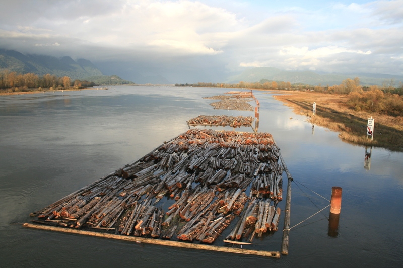
| Prairie Avenue → Dominion Avenue North Pitt River | 1.5 km | 20 min | 6 min | Unpaved dike. Log booms and boats on the Pitt River. |
| Dominion Avenue → Peace Park South Pitt River | 4.9 km | 1 hr 05 min | 20 min | The longest leg. Passes the Pitt River Bridge and the CPR yard. |
| Peace Park → Pitt River Road South Pitt River | 1.4 km | 19 min | 6 min | Paved. Citadel Landing boardwalk, views to Douglas Island. |
| Pitt River Road → Shaughnessy Street South end / Mary Hill | 2.2 km | 29 min | 9 min | Links the Pitt River side to the Coquitlam River side. |
| Shaughnessy Street → Red Bridge ƛ̓éxətəm Regional Park (Colony Farm) | 4.2 km | 56 min | 17 min | Unpaved. Floodplain marsh and some of the best birding in the region. |
| Red Bridge → Gates Park Downtown / Coquitlam River | 1.5 km | 20 min | 6 min | Paved, tree-lined river path. |
| Gates Park → Lions Park Downtown / Coquitlam River | 1.0 km | 13 min | 4 min | Paved. Washrooms, playgrounds, picnic spots. |
| Lions Park → Hyde Creek Rec Centre Coquitlam River / Hyde Creek | 3.9 km | 52 min | 16 min | Gravel north of Lougheed. Side channels, ponds, salmon. |
| Full loop | 25.3 km | 5 hr 37 min | 1 hr 41 min | Moving time only. Add time for stops. |
Clockwise or counter-clockwise? The route is flat, so either works. On a summer morning, going clockwise from Hyde Creek gets the exposed, shadeless dike sections done before the midday heat and saves the tree-lined downtown river path for later.
The best entrance points (and where to park)
You can join the trail from dozens of street ends and footbridges. These are the starts I’d point a first-timer to, depending on what they want to see.
1. Hyde Creek Recreation Centre — best all-round start
1379 Laurier Avenue. The recreation centre has its own parking and sits right on the trail, which is why the PoCo Trail Relay starts and finishes here. From the building you can head north and east toward DeBoville Slough and the Pitt River, or south along Hyde Creek and the Coquitlam River. In October and November, walk a few minutes along the creek to the Hyde Creek Education Centre & Hatchery (3636 Coast Meridian Road) to look for spawning salmon.
2. Gates Park — best for families and cyclists
2300 Reeve Street. Gates Park has public washrooms, a drinking fountain, a concession, an outdoor gym and a bicycle tire repair station, which makes it the most practical base on the whole loop. Parking is off Reeve Street and Wilson Avenue, and it gets busy when the sports fields are in use. From here the paved downtown river path runs 1.0 km north to Lions Park and 1.5 km south to the Red Bridge.
3. Shaughnessy Street and the PoCo Climb — best for a workout
The City’s PoCo Climb starts on Shaughnessy Street (the City uses 1500 Shaughnessy as the start point) and climbs more than 200 stairs from about 5 m to 75 m above sea level, up to Eastern and Western Drive. The City notes street parking on Shaughnessy Street, Eastern Drive and Western Drive. A flashing-beacon crosswalk links the stairs to ƛ̓éxətəm Regional Park, so you can do the stairs, then cool down on the flat marsh trail toward the Red Bridge (4.2 km).
4. Lions Park — best with kids or dogs
Lions Park sits on the Coquitlam River at the north end of the paved downtown stretch, with a playground and a reservable picnic shelter. The off-leash Lions Dog Park (2300 Lougheed Highway) is nearby, so it’s a natural start if your dog needs an off-leash run before or after a leashed walk.
5. DeBoville Slough — best for the views
The City of Coquitlam lists the DeBoville Slough Trail at 4100 Cedar Drive. It’s the gateway to the north dike: wetlands and berry farms on one side, the Pitt River and the Coast Mountains on the other. I couldn’t confirm a public parking lot at this end, so the simplest plan is to park at Hyde Creek Recreation Centre and walk in: it’s 1.8 km.
6. Peace Park and Citadel Landing — best for a quiet riverside stroll
On the South Pitt River side, Peace Park has a reservable picnic shelter, and the Citadel Landing boardwalk looks across the Pitt River to Douglas Island. It’s a good choice if you live in Citadel or Mary Hill and want a paved, flat out-and-back.
Washrooms are sparse. The City’s own trail guide warns about this. Gates Park has the most reliable public washrooms on the route, and Hyde Creek Recreation Centre has facilities during opening hours. Bring water: there’s a fountain at Gates Park, and very little else on the dikes.
Section by section: what you’ll see
The City describes the loop as five sections. Here’s what each one is like on the ground.
DeBoville Slough and the North Pitt River

This is the postcard part of the trail. The unpaved dike runs along DeBoville Slough and then the Pitt River, with wetland habitat, farmland and wide views of the Golden Ears. On the water you’ll see boats and log booms. The City’s guide lists belted kingfishers, ospreys, green herons, bald eagles and the occasional greater sandhill crane here. There’s almost no shade, so bring a hat in summer and expect wind in winter.
Best for: sunset walks, photography, birding. Surface: unpaved, firm in dry weather and puddly after rain.
The South Pitt River

Heading south, the trail is paved and runs past the CPR freight and repair yard, other river industry and the cable-stayed Pitt River Bridge on Lougheed Highway. When the new bridge opened in 2009, the trail got pedestrian and cycling lanes on, beside and under it, and the City finished the loop in 2010. Further south, Peace Park and the Citadel Landing boardwalk look out to Douglas Island. The City’s guide lists bald eagles and cormorants along this stretch.
Best for: easy paved riding, bridge and river views. Surface: paved.
ƛ̓éxətəm Regional Park (formerly Colony Farm)

The trail crosses the historic Colony Farm lands, now ƛ̓éxətəm (tla-hut-um) Regional Park: a floodplain of marsh, old fields and forest along the lower Coquitlam River. The City counts more than 150 bird species here, including short-eared owls, great blue herons and northern harriers, plus river otters, beavers and salmon. Red-winged blackbirds call from the marsh every spring.

Best for: birding and quiet, early-morning walks. Surface: unpaved. Heads-up: this low-lying stretch is the first to flood. In December 2025 the City closed sections under the Red Bridge and the Kingsway Avenue bridge, along with part of the Patricia footbridge area, during high water.
Downtown, along the Coquitlam River

Between the Red Bridge, Gates Park and Lions Park, the trail is a paved, tree-lined river path that’s popular with inline skaters, strollers and young kids on bikes. It passes behind residential streets and close to downtown Port Coquitlam, so it’s easy to add a coffee stop. Watch the river in fall for migrating salmon. The City’s heritage panels along this stretch, rewritten with kʷikʷəƛ̓əm First Nation, tell the story of the river.
Best for: strollers, kids’ first bike rides, short loops. Surface: paved.
The Coquitlam River and Hyde Creek
North of Lougheed Highway the trail turns to gravel and gets wilder: side channels, ponds and the Hyde Creek hatchery. The City’s guide lists pileated woodpeckers, cedar waxwings and Steller’s jays, and if you’re lucky, painted turtles near the ponds.
Best for: salmon viewing in fall, shade on hot days. Surface: gravel.
Highlights and viewpoints you shouldn’t miss
- Golden Ears from the North Pitt River dike. The best mountain view on the loop. Go late in the day for the light.
- Log booms and river traffic on the Pitt River. A working river, right beside a quiet dike.
- The Pitt River Bridge. Ride on, beside or under it; the cable-stayed towers make a great photo from the dike.
- Citadel Landing boardwalk. A short, paved boardwalk looking across to Douglas Island.
- ƛ̓éxətəm Regional Park marshes. Herons, harriers and owls. Bring binoculars.
- The PoCo Climb stairs. Views over ƛ̓éxətəm from the top, and the closest thing to a hill on the whole trail.
- Hyde Creek salmon. Chum from October to November and coho in November, with lookouts and a footbridge by the hatchery.
- Heritage panels on the Coquitlam River. Short reads about the river’s history, rewritten with kʷikʷəƛ̓əm First Nation.
Five routes I’d suggest
| Route | Distance | Time | Why |
|---|---|---|---|
| Gates Park ↔ Lions Park | 2 km return | About 30 min walking | Paved, shaded, washrooms at Gates Park. Perfect with a stroller or a young rider. |
| Hyde Creek → DeBoville Slough → Prairie Ave | 4.7 km one way | About 1 hr walking | The Golden Ears views. Turn around or arrange a pickup at Prairie Avenue. |
| Shaughnessy St → Red Bridge (plus PoCo Climb) | 4.2 km one way | About 1 hr walking + stairs | Stairs for a workout, then flat marsh trail through ƛ̓éxətəm. |
| Downtown river loop: Red Bridge → Gates Park → Lions Park | 2.5 km one way | About 35 min walking | The easiest paved stretch of the trail, close to downtown coffee. |
| The full loop by bike from Gates Park | 25.3 km | 2–3 hr with stops | Start and finish at the bike repair station and washrooms. |
Rules, safety and trail etiquette
- Dogs: on leash and under control, and pick up after them. Off-leash runs are at Lions Dog Park (2300 Lougheed Hwy) and Shaughnessy Dog Park (3345 Shaughnessy St).
- Bikes and skates: control your speed, keep right and use a bell when passing.
- E-bikes: allowed for riders 16 and older wearing a helmet, at a safe speed, yielding to pedestrians (City rules, July 2026). E-scooters aren’t permitted on PoCo pathways, and e-dirt bikes are banned on all trails.
- Horses: share the trail and give them room.
- No motor vehicles or campfires.
- Bears: they follow the salmon in fall. Make noise, keep dogs leashed, and report a bear on City trails to 604-927-5480. For a bear acting aggressively, call the Conservation Officer Service at 1-800-663-9453.
- Emergencies: the City added emergency location markers with ID codes at key entry points in 2022. If you call 911, read out the code on the nearest marker.
- Floods and closures: low sections near the Coquitlam River can close in heavy rain. Check the City’s notices before a winter outing.
Events: the PoCo Trail Relay
The PoCo Run Club’s PoCo Trail Relay runs the whole loop each late summer, starting and finishing at Hyde Creek Recreation Centre. Runners go solo or split it into four legs for teams of two to four. The 2026 edition was on Sunday, September 6 (listed at 25.3 km), and the 2025 race drew about 150 runners. If you want a goal for next year, it’s a friendly way to cover the full trail.
A little history
The trail started as an idea for Canada’s Centennial in 1967. From the early 1970s, volunteers known as the PoCo Trail Blazers began building it piece by piece. Council adopted an upgrade plan in 1997, and in 2001 the City renamed it the Traboulay PoCo Trail after Len Traboulay, Port Coquitlam’s 13th mayor, who served 19 years. The last major links came with the new Pitt River Bridge, and in 2010 the City’s parks manager said the original vision of a full loop was complete “in most senses.”
Living near the trail: which neighbourhoods back onto it
For a lot of buyers, the PoCo Trail is one of the quiet reasons Port Coquitlam ends up on the shortlist. Because it loops the whole city, the question usually isn’t whether you’ll be near it, but which section you’ll be near.
- Downtown Port Coquitlam: condos and townhomes a few blocks from the paved river path, Gates Park and Lions Park.
- Oxford Heights and River Springs: north-side family neighbourhoods close to the gravel Coquitlam River and Hyde Creek sections.
- Citadel Heights and Mary Hill: above the South Pitt River and ƛ̓éxətəm, with the PoCo Climb as your shortcut down to the trail.
My honest advice: walk the stretch closest to a home before you buy. A dike-top view of the Golden Ears and a shady river path feel very different at 7 a.m. in January, and flood-prone low spots matter if you’re planning daily runs or a stroller commute.
Frequently asked questions
How long is the Traboulay PoCo Trail?
The City of Port Coquitlam describes it as a 25-kilometre loop. The City’s trail guide breaks it into ten legs that add up to 25.3 km, and the City used the 25.3 km figure again in a January 2025 release. It circles the whole city along the Coquitlam River, the Pitt River and DeBoville Slough.
How long does it take to walk the whole PoCo Trail?
At an average walking pace of about 4.5 km/h, the full 25.3 km loop is roughly 5 hours 40 minutes of walking, so plan on a full day with breaks. Most people walk it in sections: each of the ten legs takes between 15 minutes and just over an hour on foot.
How long does it take to bike the PoCo Trail?
At a relaxed 15 km/h the loop is about 1 hour 40 minutes of riding. With stops for views and photos, 2 to 3 hours is realistic, which matches the roughly 2.5 hours Trails BC suggests for its cycling loop. A hybrid or gravel bike handles the unpaved dike and gravel sections best.
Where is the best place to park for the PoCo Trail?
Three easy starting points are the Hyde Creek Recreation Centre (1379 Laurier Avenue), Gates Park (2300 Reeve Street, with washrooms, a drinking fountain and a bike repair station) and Shaughnessy Street near the PoCo Climb, where the City notes street parking. Pick the one closest to the section you want to see.
Is the Traboulay PoCo Trail paved?
Partly. The City says the Downtown and South Pitt River sections are paved, the stretch north of Lougheed Highway is gravel, and the DeBoville Slough and North Pitt River section is unpaved. Strollers and road bikes do best on the paved Downtown stretch between the Red Bridge, Gates Park and Lions Park.
Are dogs allowed on the PoCo Trail?
Yes, on leash. The City’s trail guide asks owners to keep dogs leashed and under control and to pick up after them. If your dog needs to run, the Lions Dog Park (2300 Lougheed Highway) and Shaughnessy Dog Park (3345 Shaughnessy Street) are off-leash areas close to the trail.
Are e-bikes allowed on the Traboulay PoCo Trail?
Yes. According to the City’s July 2026 e-mobility rules, e-bike riders must be at least 16 and wear a helmet, and on shared pathways like the PoCo Trail they should keep a safe speed, use a bell and yield to pedestrians. E-scooters are not permitted on PoCo pathways, and electric dirt bikes are banned on all trails.
When can you see salmon on the PoCo Trail?
Fall is the season. The Pacific Salmon Foundation lists chum salmon in Tri-Cities streams from October to November and coho in November, with pink salmon in odd-numbered years only. Hyde Creek (by the hatchery at 3636 Coast Meridian Road), the Coquitlam River and the Oxbow side channel are good places to look. Bears also follow the salmon, so stay alert.
Why is it called the Traboulay PoCo Trail?
The trail began as an idea for Canada’s 1967 Centennial and was built from the early 1970s by volunteers called the PoCo Trail Blazers. In 2001 it was renamed to honour Len Traboulay, Port Coquitlam’s 13th mayor, who served for 19 years.
Sources & Methodology
This guide relies first on the City of Port Coquitlam, with regional and local sources for detail the City doesn’t publish:
- City of Port Coquitlam — Traboulay PoCo Trail page and 2026 Trail Map & Guide (portcoquitlam.ca/traboulay). Source for: 25 km length, sections, surfaces, permitted users, wildlife, emergency markers and history.
- City of Port Coquitlam — Traboulay PoCo Trail brochure (2012) (PDF). Source for: the ten leg distances (25.3 km total), trail rules, sparse washrooms, picnic shelters and bear safety numbers.
- City of Port Coquitlam — PoCo Climb page and January 30, 2025 release (portcoquitlam.ca). Source for: stairs, elevation, start point and street parking.
- City of Port Coquitlam — Gates Park, dog parks, e-mobility rules (July 14, 2026) and December 2025 flooding notices (Gates Park, e-mobility, flooding).
- City of Coquitlam — DeBoville Slough Trail (coquitlam.ca). Source for: 4100 Cedar Drive and the north dike description.
- Pacific Salmon Foundation — salmon spotting in the Tri-Cities (psf.ca). Source for: salmon timing, Hyde Creek hatchery and Hyde Creek Recreation Centre addresses.
- Trails BC, Fraseropolis and Georgia Straight (2010) for cycling time estimates and the trail’s completion history; Race Roster and the City of Port Coquitlam for PoCo Trail Relay details.
Methodology: walking and cycling times are my own calculations from the City’s leg distances at 4.5 km/h and 15 km/h, and they don’t include stops. Leg distances come from the City’s 2012 brochure; an older City map shows a shorter Dominion Avenue to Peace Park leg (4.0 km) and a 24.4 km total. Trail conditions change, so check City notices before you go. Photos are from Wikimedia Commons under the Creative Commons licences credited under each image. Facts checked October 11, 2026.
Signed: Craig Johnston, REALTOR® V99960 · Royal LePage Elite West
Want a home near the PoCo Trail?
I’ll help you find the streets that put the trail section you’ll actually use within a few minutes’ walk, and price them against recent sales in the same pocket of Port Coquitlam.
Direct: 604-202-6092 · Craig@SoldByCraig.ca